
UN Votes to ‘Correct the Map’ After African Union Push on Africa’s True Size
NEW YORK / ADDIS ABABA — 5 September 2026
The United Nations General Assembly has adopted resolution A/80/L.104, titled “Correct the Map”, encouraging governments, schools and international organisations to move away from the 16th-century Mercator projection towards equal-area maps that more accurately show the size of continents, particularly Africa.
The resolution, tabled by Togo on behalf of the African Group and backed by the African Union, passed with 164 votes in favour. The United States cast the sole vote against. Six countries abstained.
The text states that the Mercator projection, still widely used in classrooms, media and official documents, inflates landmasses nearer the poles and shrinks those closer to the equator. On many Mercator maps, Greenland appears similar in size to Africa. In reality, Africa is about 14 times larger.
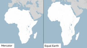
The resolution highlights the 2018 Equal Earth projection as a more accurate option for showing relative land area. It does not ban the Mercator projection, which remains useful for navigation, and is not legally binding. It instead urges member states and institutions to adopt equal-area maps where the comparison of size matters.
The vote follows an African Union campaign launched in August 2025. The AU argued that long-standing cartographic distortions have contributed to a “symbolic minimisation” of Africa in education, media and public perception. Ethiopian scholar Mehari Taddele Maru and other African academics have welcomed the decision as long overdue.
Hahu Prime notes that the resolution is framed by its sponsors as an act of “cognitive justice” rather than a technical cartographic update. Supporters say maps shape how generations understand the world. Critics, including the United States, described the initiative as an unnecessary distraction from more pressing global problems.
The African Union and several member states are expected to press UN agencies, development banks and digital map providers to review the projections they use in official materials.